Choosing free drone mapping software is harder than it looks. The term covers three distinct categories — freemium cloud platforms, open-source self-hosted tools, and capped personal-use editions — and each solves a different problem. Some options are easy to start but limited in scale. Others are fully capable drone mapping software but demand real technical setup. The right pick depends on whether your priority is speed, open-source control, or learning without a credit card gate. This guide compares the five most viable free options side by side so you can choose based on your actual workflow, not marketing language. For a broader overview of drone mapping methods including photogrammetry and videogrammetry, see our aerial photogrammetry guide.
Key Takeaways
- Free drone mapping tools fall into three distinct categories — freemium cloud software, open-source self-hosted tools, and free personal-use editions — and treating them as equivalent wastes time.
- SkyeBrowse Freemium starts at $0/month with unlimited 2D and 3D modeling and pay-per-model unlocks from $3, making it the lowest-friction entry point for anyone evaluating drone mapping software.
- WebODM is the strongest truly free option for open-source users: it generates orthomosaics, point clouds, DEMs, and 3D models from aerial images with no license fee, but requires self-hosting via Docker.
- 3DF Zephyr Free caps projects at 50 photos, making it useful for learning photogrammetry but impractical for production drone mapping missions.
- SkyeBrowse accepts drone video directly (videogrammetry) and requires no ground control points, while photo-based tools like WebODM and Meshroom need overlapping grid-flight images and GCPs for accuracy.
- Free software is rarely a complete substitute for production workflows once jobs become time-sensitive, collaborative, or compliance-driven.
Contents
- What is drone mapping software and how does the free tier work?
- Which free drone mapping tools are actually worth trying?
- How do these free drone mapping tools compare head-to-head?
- Which free option is best for open-source users?
- What are the real limits of free drone mapping software?
- FAQ
What is drone mapping software and how does the free tier work?
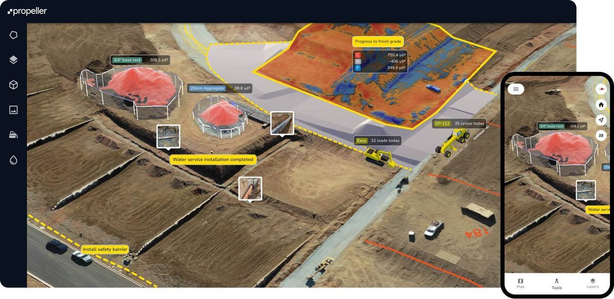
Drone mapping software is any application that processes aerial drone footage or images into georeferenced deliverables: orthomosaics (stitched top-down maps), 3D models, point clouds, or digital elevation models. In 2026, free drone mapping software means one of three things — a freemium cloud product, an open-source self-hosted tool, or a free personal-use edition with significant processing limits. Those categories are not interchangeable.
That distinction shapes your decision more than any feature list. A freemium cloud product like SkyeBrowse gives you browser-based access and real outputs at $0 — but the most powerful processing tiers are paid. An open-source tool like WebODM costs nothing in license fees but runs on your machine and requires Docker setup. A personal-use edition like 3DF Zephyr Free is essentially a learning tool with a 50-photo cap per project.
The USGS National Geospatial Program documents how aerial survey data from drones is used for scientific and government mapping — the same underlying photogrammetry that powers all five tools on this list. Photogrammetry (using overlapping images to extract depth and geometry) is the dominant technique, though videogrammetry — used by SkyeBrowse — processes continuous video frames instead of discrete photos, reducing the setup burden of grid-flight planning.
The practical categories:
- Freemium cloud software: easiest to start, results in the browser, advanced tools unlock with payment
- Open-source self-hosted software: highest control and no license cost, but most technical overhead
- Free personal-use editions: good for learning and small tests, too limited for regular fieldwork
Which free drone mapping tools are actually worth trying?
The free drone mapping tools most worth trying in 2026 are SkyeBrowse Freemium, WebODM, 3DF Zephyr Free, Meshroom, and QGIS as an analysis layer. They earn consideration for different reasons — not because they all compete head-to-head for the same use case.
Here is the short version of each tool:
| Tool | Best for | Key constraint |
|---|---|---|
| SkyeBrowse Freemium | Fast browser-based results, video input | Higher-accuracy models require paid credits |
| WebODM | Open-source aerial photo mapping | Self-hosted, Docker required |
| 3DF Zephyr Free | Learning photogrammetry concepts | 50-photo cap per project |
| Meshroom | Photogrammetry research and experimentation | GPU (CUDA) required, not aerial-mapping-focused |
| QGIS | Free GIS analysis of mapping outputs | Not a photogrammetry engine — analysis only |
SkyeBrowse is the only tool on this list that uses videogrammetry — processing continuous video instead of a grid of overlapping photos. That distinction matters for buyers who want to skip grid-flight planning and GCP placement. The SkyeBrowse pricing page lists Freemium at $0 per month with unlimited 2D and 3D modeling and pay-per-model unlocks starting at $3. Users who want a step-by-step walkthrough of the SkyeBrowse free workflow can find it in the SkyeBrowse for Beginners guide.
How do these free drone mapping tools compare head-to-head?
Comparing free drone mapping software head-to-head reveals that no single tool wins on every dimension. SkyeBrowse Freemium leads on ease of use and cloud access. WebODM leads on open-source completeness for aerial photo workflows. 3DF Zephyr Free and Meshroom are learning tools, not production platforms; QGIS is a post-processing layer, not a mapping engine.
Free Drone Mapping Software Comparison
| Feature | SkyeBrowse Freemium | WebODM | 3DF Zephyr Free | Meshroom | QGIS |
|---|---|---|---|---|---|
| Cost | $0 (pay-per-model from $3) | Free (self-hosted) | Free (personal use) | Free (open-source) | Free (open-source) |
| Input type | Video or photos | Photos | Photos | Photos | N/A (viewer/analyzer) |
| Cloud processing | Yes | No (local only) | No (local only) | No (local only) | N/A |
| Orthomosaic output | Yes | Yes | No | No | View only |
| 3D model output | Yes | Yes | Yes (50-photo cap) | Yes | View only |
| Point cloud export | LAZ | LAZ, PLY | PLY, OBJ | PLY, OBJ | View only |
| DEM/DSM generation | No | Yes | No | No | Analysis only |
| Photo/video limit | None (video-based) | None | 50 photos per project | None | N/A |
| GCPs required | No | Recommended for accuracy | Recommended | Recommended | N/A |
| GPU required | No | No (CPU) | No | Yes (CUDA) | No |
| Setup difficulty | None (browser) | Moderate (Docker) | Low (installer) | Moderate (build/install) | Low (installer) |
| Collaboration/sharing | Built-in link sharing | Manual export | Manual export | Manual export | Manual export |
| Best fit | Beginners, fast results | Open-source aerial mapping | Learning photogrammetry | Photogrammetry research | Post-processing analysis |
These platforms all function as photogrammetry software for drones, converting raw aerial captures into usable deliverables. The most important buying truth: free does not mean complete. Buyers who need formal survey accuracy, team collaboration, or compliance-ready exports will eventually hit the ceiling of every tool in this table.

Which free option is best for open-source users?
WebODM is the best free option for open-source users who want complete drone photo mapping without a license fee. It is the most capable no-cost aerial mapping platform on this list, but it requires the user to accept self-hosting and ongoing infrastructure management.
The official WebODM page describes it as generating maps, point clouds, DEMs, and 3D models from aerial images, running entirely on your own hardware — including offline. That is real, production-grade capability. It is also real responsibility: you own the compute, storage, software updates, and troubleshooting.
For users exploring other open-source paths:
- 3DF Zephyr Free is useful for learning photogrammetry from scratch, but its 50-photo cap is a hard wall for any real mapping mission.
- Meshroom's current releases show active development, but Meshroom targets object reconstruction more than aerial drone mapping — expect tuning time.
- QGIS is one of the strongest free GIS tools available and handles GeoTIFFs, point clouds, and shapefiles well — but it does not generate photogrammetric models; it analyzes outputs from tools that do.
If the requirement is "photogrammetry software free and open-source for aerial datasets," WebODM is the clearest answer. For a deeper comparison of WebODM against SkyeBrowse across accuracy, workflow, and total cost, see the WebODM review.
What are the real limits of free drone mapping software?
The limits of free drone mapping software are not usually about whether a tool can generate a map at all. The real limits are processing speed, project size, export flexibility, collaboration features, and the operator skill required to get repeatable results — all of which compound once work becomes regular and commercial.
That is why the right evaluation question is not "can this free tool make a map?" but "can it reliably make the map I need, at the pace I need, across a full project season?" The honest answer varies by category:
- Learning and experimentation: free tools are usually adequate
- Occasional small projects: freemium or personal-use editions are often sufficient
- Repeat commercial mapping: the time cost of free tools starts accumulating quickly
- Formal surveying or regulated workflows: process discipline and output validation matter far more than license price
Free software is a legitimate entry point for any buyer, but it is rarely a full substitute for a production workflow once jobs become time-sensitive, team-based, or compliance-driven. For buyers evaluating what to step up to, the drone mapping software guide compares the full market, and the DroneDeploy alternatives guide covers how leading paid platforms stack up.

FAQ
What is the best free drone mapping software?
The best free drone mapping software depends on your workflow. SkyeBrowse Freemium is the easiest no-setup option — browser-based, no GCPs, video input accepted, with free 2D and 3D models and pay-per-model credits from $3. WebODM is the strongest fully free open-source option for teams comfortable with Docker and self-hosting. 3DF Zephyr Free and Meshroom work for learning but hit hard limits in production. If you are just getting started, the SkyeBrowse for Beginners guide walks through the full capture-to-output workflow step by step.
Is drone mapping software available for free?
Yes. Legitimate free drone mapping software exists in three forms: freemium cloud platforms (SkyeBrowse Freemium), open-source self-hosted tools (WebODM, OpenDroneMap, Meshroom), and free personal-use editions with processing caps (3DF Zephyr Free). Each has real trade-offs in setup complexity, capability ceiling, and long-term scalability. The drone mapping guide explains the full range of methods and what distinguishes free from paid tiers.
What is the difference between free and paid drone mapping software?
Free drone mapping software typically limits output resolution, project size, export formats, and customer support. Paid tiers add higher-accuracy processing, team collaboration, cloud storage, compliance-ready outputs, and priority support. For occasional personal use, free tools are often sufficient. For time-sensitive commercial work, paid tiers typically recover their cost within a few jobs.
Can free drone mapping software produce professional-quality results?
Sometimes. WebODM can generate survey-grade orthomosaics and point clouds from well-captured aerial photos when combined with ground control points and disciplined flight planning. However, free tools rarely match the processing speed, team features, and compliance documentation that professional survey firms need at scale.
Which free drone mapping app works without a local computer?
SkyeBrowse Freemium is fully browser-based and processes everything in the cloud, so no local installation is needed. The SkyeBrowse Flight App also runs on iOS and Android for capture. All other major free options — WebODM, 3DF Zephyr Free, Meshroom — require a local computer with sufficient processing power.